Burleigh County, North Dakota
| Burleigh County, North Dakota | |
Location in the state of North Dakota |
|
North Dakota's location in the U.S. |
|
| Founded | 1873 |
|---|---|
| Named for | Walter A. Burleigh |
| Seat | Bismarck |
| Largest city | Bismarck |
| Area - Total - Land - Water |
1,668 sq mi (4,320 km²) 1,633 sq mi (4,229 km²) 35 sq mi (91 km²), 2.10% |
| Population - (2010) - Density |
81,308 41/sq mi (16/km²) |
| Website | www.co.burleigh.nd.us |
Burleigh County is a county located in the U.S. state of North Dakota. As of 2010, the population was 81,308.[1] Its county seat is Bismarck.[2] Burleigh County and Morton County make up the "Bismarck, ND Metropolitan Statistical Area" or "Bismarck-Mandan".
Contents |
Geography
According to the U.S. Census Bureau, the county has a total area of 1,668 square miles (4,320.1 km2), of which 1,633 square miles (4,229.5 km2) is land and 35 square miles (90.6 km2) (2.10%) is water.
Townships
|
|
|
Major highways
|
|
Adjacent counties
- Sheridan County (north)
- Kidder County (east)
- Emmons County (south)
- Morton County (southwest)
- Oliver County (west)
- McLean County (northwest)
| McLean County | Sheridan County | |||
| Oliver County | Kidder County | |||
| Burleigh County, North Dakota | ||||
| Morton County | Emmons County |
National protected areas
- Canfield Lake National Wildlife Refuge
- Florence Lake National Wildlife Refuge
- Long Lake National Wildlife Refuge (part)
Demographics
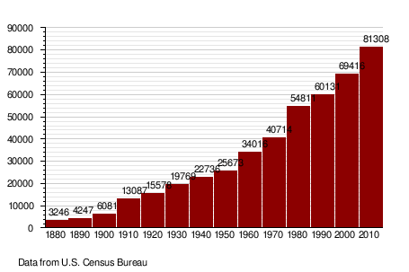
| Historical populations | ||
|---|---|---|
| Year | Pop. | ±% |
| 1880 | 3,246 | — |
| 1890 | 4,247 | +30.8% |
| 1900 | 6,081 | +43.2% |
| 1910 | 13,087 | +115.2% |
| 1920 | 15,578 | +19.0% |
| 1930 | 19,769 | +26.9% |
| 1940 | 22,736 | +15.0% |
| 1950 | 25,673 | +12.9% |
| 1960 | 34,016 | +32.5% |
| 1970 | 40,714 | +19.7% |
| 1980 | 54,811 | +34.6% |
| 1990 | 60,131 | +9.7% |
| 2000 | 69,416 | +15.4% |
| 2010 | 81,308 | +17.1% |
| 2010 Est | 81,666 | +0.4% |
|
|
||
As of the census[3] of 2000, there were 69,416 people, 27,670 households, and 18,206 families residing in the county. The population density was 42 people per square mile (16/km²). There were 29,003 housing units at an average density of 18 per square mile (7/km²). The racial makeup of the county was 95.03% White, 0.26% Black or African American, 3.28% Native American, 0.40% Asian, 0.03% Pacific Islander, 0.16% from other races, and 0.85% from two or more races. 0.67% of the population were Hispanic or Latino of any race. 56.9% were of German and 14.9% Norwegian ancestry according to Census 2000.
There were 27,670 households out of which 32.60% had children under the age of 18 living with them, 54.0% were married couples living together, 8.7% had a female householder with no husband present, and 34.2% were non-families. 28.1% of all households were made up of individuals and 9.5% had someone living alone who was 65 years of age or older. The average household size was 2.42 and the average family size was 2.99.
In the county the population was spread out with 24.7% under the age of 18, 11.0% from 18 to 24, 29.3% from 25 to 44, 22.5% from 45 to 64, and 12.4% who were 65 years of age or older. The median age was 36 years. For every 100 females there were 95.50 males. For every 100 females age 18 and over, there were 93.5 males.
The median income for a household in the county was $41,309, and the median income for a family was $52,085. Males had a median income of $34,753 versus $22,473 for females. The per capita income for the county was $20,436. About 5.30% of families and 7.80% of the population were below the poverty line, including 8.80% of those under age 18 and 7.50% of those age 65 or over.
Population by decade
Places
Cities
Note: all incorporated communities in North Dakota are called "cities" regardless of their size.
Unincorporated communities
See also
References
- ^ "2010 Census Redistricting Data (Public Law 94-171) Summary File". American FactFinder. United States Census Bureau. http://factfinder2.census.gov/faces/tableservices/jsf/pages/productview.xhtml?pid=DEC_10_PL_GCTPL2.ST05&prodType=table. Retrieved 3 May 2011.
- ^ "Find a County". National Association of Counties. http://www.naco.org/Counties/Pages/FindACounty.aspx. Retrieved 2011-06-07.
- ^ "American FactFinder". United States Census Bureau. http://factfinder.census.gov. Retrieved 2008-01-31.
|
||||||||||||||||||||||||||
|
||||||||||||||